What makes landscape architecture different from other design disciplines is that a landscape is never truly finished. Buildings tend to remain fixed over time, but landscapes are alive. Trees grow, shrubs spread, leaves fall, flowers bloom, and every season changes how a space looks and performs.
That is why choosing the right landscape design software matters. Designers need tools that do more than draw plans. They need software that helps them understand terrain, planting design, seasonal change, shade, and long-term plant development. A landscape project is not only about how it looks on the day of construction, but also about how it evolves over the years.
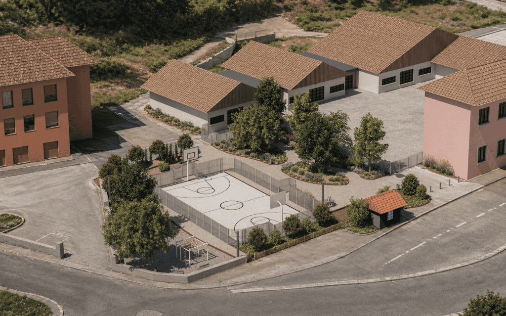
A strong example of this approach is the redesign of a school entrance in Corveissiat, France. In this project, landscape designer Stephanie Berthier transformed a hard, concrete-dominated entrance into a more welcoming outdoor space with vegetation, shade, rest areas, and spaces for play. Using RhinoLands landscape design software, the project could be developed with real site data, accurate planting information, and realistic seasonal visualization.
Why Landscape Design Software Matters in Modern Planting Design
In landscape architecture, every design decision has long-term consequences. Tree placement affects future shade. Plant selection influences maintenance, biodiversity, and climate adaptation. Groundcover and shrubs shape the spatial experience across the seasons.
This is where advanced landscape design software becomes essential. Instead of separating technical drawings from planting studies and visualization, designers can work in one environment where all these elements remain connected. That makes it easier to move from concept to construction documentation while keeping the design intent clear.
For the Corveissiat school project, the goal was not just to add greenery. The goal was to create a more comfortable and functional public space for children, supported by planting choices that respond to the site and its future use.
Starting with the Real Site: Terrain, Buildings, and Geolocation
Every successful landscape project starts with context. In RhinoLands, terrain import tools allow designers to bring in topography, roads, and existing buildings directly into the model. This means the design begins with the real physical conditions of the site, not with abstract geometry.
Working with geolocated site data inside the same landscape design software helps designers make better early decisions. Real coordinates and solar position can be used to study sun exposure and shadow behavior throughout the year. This is especially useful in public projects where comfort matters.
In the Corveissiat entrance redesign, this made it possible to position larger trees strategically so that rest areas and play zones would receive shade at the right moments of the day and during the warmer seasons. Instead of guessing, the designer could evaluate these conditions directly in the model.
Real-Time Solar Analysis for Smarter Outdoor Design
One of the most valuable features in professional landscape design software is real-time solar analysis. Shade is not only a visual effect; it directly affects comfort, usability, and microclimate.
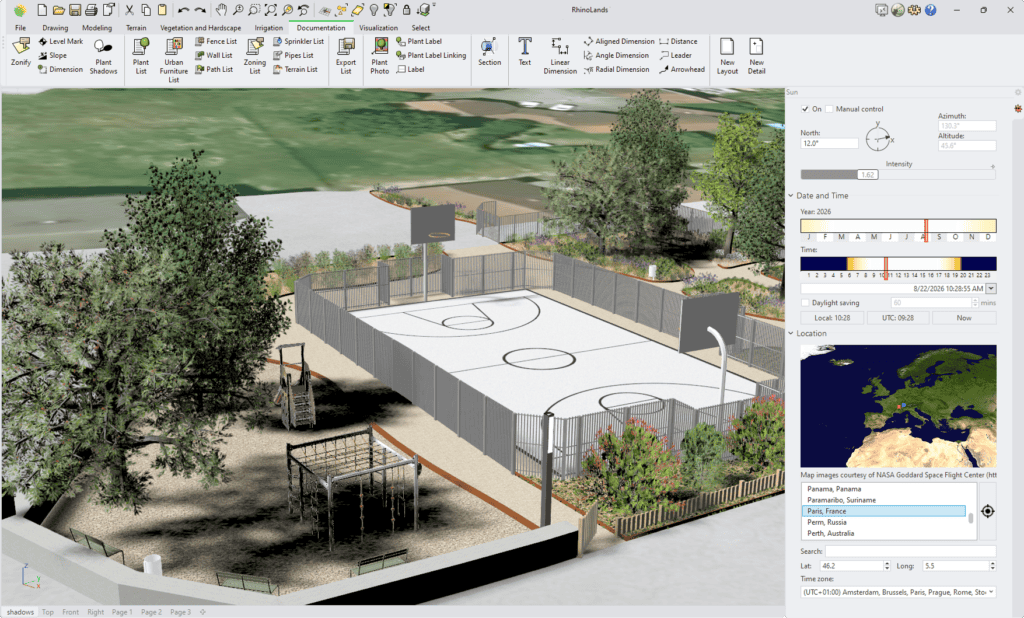
By studying the sun path and live shadows in the 3D model, designers can understand how planting and built elements interact over time. This is particularly important in schools, parks, plazas, and other public spaces where shade can improve everyday use.
In this project, solar analysis supported the placement of trees to create cooler and more usable outdoor areas. This approach turns landscape design into a more informed process, where environmental performance and user comfort are part of the design from the beginning.
Plant Selection Based on Climate, Soil, and Water Needs
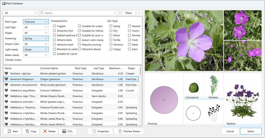
Good planting design is not only aesthetic. It is also technical and ecological. The best landscape design software helps designers select species based on criteria such as climate, soil type, water requirements, maintenance level, and botanical characteristics.
For the Corveissiat project, canopy trees such as Tilia cordata and Ginkgo biloba ‘Autumn Gold’ were used to provide shade over key areas of use. At ground level, species such as Vaccinium angustifolium and Geranium pratense were chosen for their suitability to the environmental conditions of eastern France and their relatively low maintenance needs.
The design also introduced an educational and sensory dimension through edible species such as Rubus idaeus and Malus domestica. In a school environment, these choices create more than visual value. They support interaction, learning, and a closer relationship between children and planting.
With RhinoLands, designers can filter plants using exactly these kinds of criteria. This makes the plant database a practical design tool, not just a library. Searching by climate adaptation, soil preferences, or edible fruit allows ecological, functional, and pedagogical goals to become part of the planting strategy from the start.
From Planting Plan to 3D Model in One Landscape Design Workflow
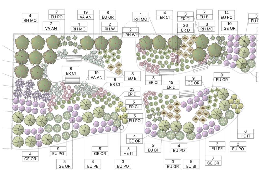
Traditional planting plans are still essential. They must remain accurate, technical, and ready for construction. But today, designers also need to communicate their ideas clearly to clients, collaborators, and public stakeholders.
This is where integrated landscape design software offers a major advantage. RhinoLands allows designers to move between 2D planting plans and a coordinated 3D landscape model without losing consistency. Crown representations, plant labels, and technical documentation stay connected to the visual model, which helps reduce repetition and improve workflow efficiency.
For landscape architects, this means the planting plan is no longer a separate final drawing produced only for documentation. It becomes part of a broader design process in which technical accuracy and visual communication support each other from the beginning.
In the Corveissiat project, the planting layout could be reviewed both as a professional 2D drawing and as a three-dimensional landscape composition. This made it easier to evaluate spatial relationships between paths, trees, shrubs, play areas, and built elements. It also helped show how the planting design would shape the everyday experience of the school entrance.
Seasonal Visualization in Landscape Design Software
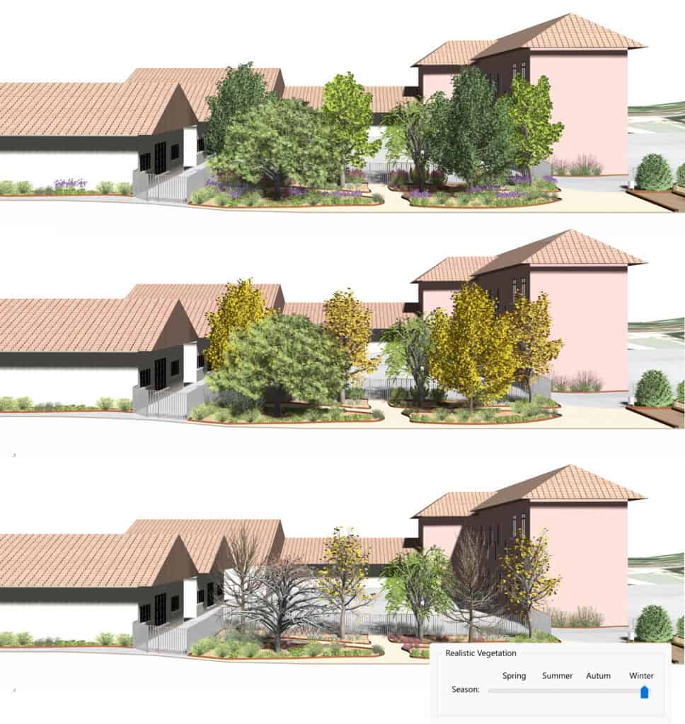
One of the biggest advantages of using professional landscape design software is the ability to visualize planting across the seasons. A landscape is never static, and planting design should not be evaluated as if it were.
Within RhinoLands, each plant is represented as a living element with its own seasonal behavior, growth pattern, crown shape, and visual character. This makes it possible to study how a design changes over time, not only in plan but also in atmosphere and spatial quality.
Seasonal simulation helps landscape architects present a project more realistically. A tree in spring does not offer the same visual density as it does in summer. Autumn color can transform the character of a public space. Winter reveals structure, openness, and visibility in very different ways. These changes matter in schools, parks, streetscapes, and residential projects, where people experience the landscape throughout the year.
For the Corveissiat school entrance, seasonal visualization supported a more informed understanding of shade, vegetation density, and visual identity over time. Instead of presenting idealized greenery under fixed conditions, the designer could show how the project would perform and appear during different moments of the year.
Landscape Design Software for Better Design Decisions
The real strength of landscape design software is not only in representation. It is in decision-making. When terrain, sun analysis, plant data, planting plans, and 3D visualization are all part of the same workflow, designers can make better choices with more confidence.
In this project, RhinoLands supported decisions about:
- tree placement for shade and comfort
- species selection based on climate and maintenance
- planting composition for biodiversity and educational value
- spatial quality across the seasons
- communication through both technical drawings and realistic visual models
This leads to a more complete and reliable design process. Instead of treating planting as a decorative layer added late in the project, it becomes a core part of how space is shaped and evaluated.
Why RhinoLands Is a Powerful Landscape Design Software Solution
For landscape architects and designers, RhinoLands brings together essential tools in a single environment: terrain modeling, geolocated site data, planting design, plant database filtering, real-time shadow analysis, seasonal visualization, and planting documentation.
As a BIM landscape design software, RhinoLands does more than help designers create drawings and visualizations. It connects design elements to project information, making the workflow more efficient, coordinated, and accurate. Plants, walls, pavements, and other landscape elements are not just graphic objects. They are intelligent elements linked to data that can be used throughout the project.
This BIM-based workflow also helps automate documentation. RhinoLands can automatically generate plant lists and quantities, as well as information related to other project elements such as walls and additional landscape components. This saves time, reduces manual work, and improves consistency between the model, the planting plan, and the final documentation.
That combination makes RhinoLands especially useful for projects where vegetation is central to the design outcome. Whether the goal is to create shade, support biodiversity, improve visual quality, or communicate a planting strategy clearly, RhinoLands helps designers work with living materials in a more precise and professional way.
The Corveissiat school project shows how landscape design software can support every stage of the process, from site analysis to planting selection and from technical plans to immersive seasonal visualization. In landscape architecture, where time and growth are part of the design itself, having tools that reflect that reality is not just helpful. It is essential.